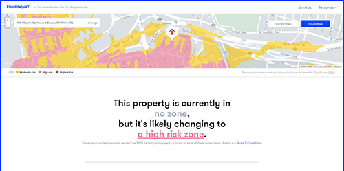
Courtesy of the Center for New York City Neighborhoods
The administration has called FloodHelpNY.org a one-stop shop for flood risk information.
By Michael V. Cusenza
The Federal Emergency Management Agency and Mayor Bill de Blasio this week announced an agreement to revise the city’s flood maps.
According to the administration, Monday’s pact announcement is the result of the City’s appeal of FEMA’s 2015 Preliminary Flood Insurance Rate Maps. In a June 2015 letter to FEMA Region 2 Mitigation Director Michael Moriarty, NYC officials indicated that the 180-page appeal “demonstrates several errors that were made in the development of the Preliminary FIRMs that undermine their accuracy.”
The City’s analysis showed that FEMA’s flood risk calculations for the five boroughs and the surrounding region overestimated the size of the 100-year floodplain and the height of the Base Flood Elevations, mapping 35,000 more homes and buildings across the city into highest flood risk areas.
The federal agency’s flood maps require homeowners in the highest risk zones to purchase flood insurance to cover the cost of flood damage, if they have a mortgage. Revised flood maps, de Blasio noted, will provide NYC residents with more precise current flood-risk data, in addition to producing a new map product reflecting future conditions that account for climate change. The innovative revisions will assist the Big Apple in making coastlines more resilient and climate-ready, while ensuring homeowners are not required to purchase more insurance than their current flood risk requires, according to the administration.
“We are building a stronger, more resilient city to confront climate change. Our city needs precise flood maps that reflect real risks, both today and years from now—and we have to do that fairly,” de Blasio said. “We will work closely with FEMA to ensure New Yorkers in the floodplain are prepared, and that the tools to make them more resilient, like flood insurance, remain available and affordable. We are grateful to FEMA [for] agreeing to this partnership.”
Until the new flood maps are issued, insurance rates in the city will continue to be based on the prior effective FIRMs, saving coastal households tens of millions of dollars per year, in aggregate, de Blasio said. For those outside of the highest risk areas on those maps, flood insurance will remain less expensive; both FEMA and the City are encouraging residents to purchase this affordable flood coverage “because we know that there is flood risk outside of the highest risk areas.”
Until new flood maps are developed that both accurately reflect current flood risk and also provide an assessment of future climate conditions for long-term planning purposes, the City’s building code will continue to reflect the 2015 Preliminary FIRMs to ensure that new buildings are better able to withstand flood risk from rising sea levels and coastal storm surge, and so that recovery from Superstorm Sandy can continue without interruption, the administration added.
“The City’s OneNYC resiliency program requires the best-available climate science and accurate flood maps,” said Daniel Zarrilli, senior director, Climate Policy and Program and Chief Resilience Officer, Mayor’s Office. “FEMA’s decision to redraw New York City’s flood maps, and to work with us to produce innovative, climate-smart flood maps, allows us to begin separating the calculation of annual insurance premiums against current risk from the necessary long-term planning and building we need to do as a city to do adapt to rising seas and climate change. All homeowners should consider purchasing flood insurance to protect their homes and families.”
For flood risk information, visit FloodHelpNY.org.