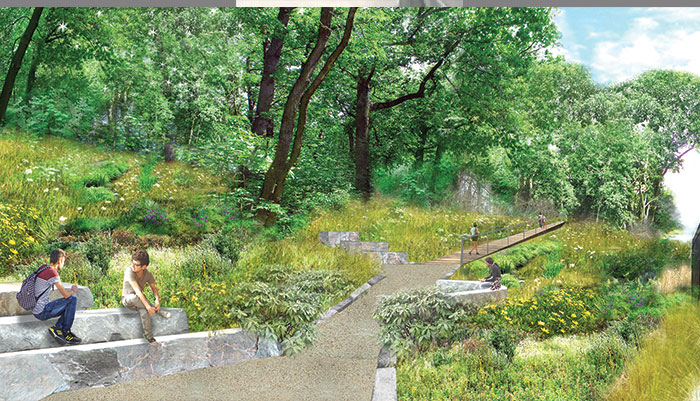
Rendering Courtesy of DLANDstudio Architecture + Landscape Architecture
According to supporters, Phase I of the QueensWay, which is next to Forest Hills and Glendale, could be built and open to the public by 2020 as a city park.
By Michael V. Cusenza
The two organizations leading the charge to establish the QueensWay announced on Monday that they have finished the schematic design for the first half-mile of the proposed linear park and trail.
The QueensWay project involves converting the long-abandoned Rockaway Beach Rail Line of the Long Island Rail Road—a 3.5-mile, 47-acre swath of the borough, from Rego Park to Ozone Park—into a $120 million public park, similar to the Highline in Chelsea, boasting trails and amenities.
The design stage of Phase I began in earnest last summer, Friends of the QueensWay and the Trust for Public Land announced in June 2016.
Phase I, which is next to the neighborhoods of Forest Hills and Glendale, could be built and open to the public by 2020 as a City park. According to the two groups, the phase dubbed “the Metropolitan Hub” will greatly improve access to Forest Park, running from Metropolitan Avenue south to Union Turnpike, where an existing path provides pedestrian and bike access to the park. This section will also provide learning gardens and outdoor classrooms for the over 2,000 students in the three schools comprising the Metropolitan Education Campus.
So far, The Trust for Public Land and Friends of the QueensWay have combined more than $2 million in private funds and State grants to move the project forward.
“Today’s announcement is a tremendous step forward for the QueensWay, which would not have been possible without our partners in government and the community, who enthusiastically provided ideas for safe routes for biking and walking, outdoor classroom space, and enhancements to baseball fields,” said Andy Stone, NYC director of The Trust for Public Land. “The completion of a compelling design for the first phase will bring us that much closer to making the QueensWay a reality for hundreds of thousands of people who live within a 10-minute walk.”
For the past several years, the debate over what to do with the span of abandoned rail track has come down to QueensWay vs. QueensRail: park land vs. public transportation in the World’s Borough.
Proponents of the QueensRail are devoted to the reactivation of the Rockaway Beach Rail Line either as part of the Long Island Rail Road or, more likely, the City subway system. The defunct spur was put into service in the late 19th Century under the control of the LIRR and connected Rockaway and southern Queens with Rego Park, provided area residents with expedient access to other parts of the city, and 40-minute commutes to Midtown Manhattan from the Rockaway Peninsula.
In April 2016, the Metropolitan Transportation Authority announced that it would conduct a feasibility study of the RBRL, including an assessment of transportation options and issues identified with restoring the QueensRail. Former MTA Chairman and Chief Executive Officer Thomas Prendergast said the agency would submit findings of the analysis by no later than June 30, 2017.
“While the Friends of the QueensWay are wasting taxpayer money on fancy schematics and consultants, a bad idea is still a bad idea,” Mike Scala, first vice president of the Queens Public Transit Committee, told The Forum on Monday. “The momentum is on the side of the QueensRail because using a transportation asset to improve public transit is the right thing to do. We eagerly await the MTA’s feasibility study.”