A group of eager cyclists showed up to a meeting on Saturday to help put central Queens on the road to bike-ability.
Congregating at Maspeth High School for a gathering organized by Community Board 5 and the Department of City Planning, about 30 cyclists armed with markers drew potential bike paths onto maps of central Queens in an effort to help the city determine where bicycle lanes and racks might be placed. They traced paths rode regularly and blazed new trails on Queens’ major arteries, including Eliot and Metropolitan avenues.

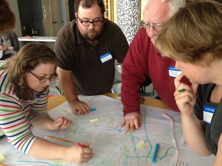
Janet Jenkins, of Maspeth, left; Christopher Crowe, of Ridgewood; Kevin Burns, of Glendale; and Jessame Hannus, of Rego Park, draw potential bike routes onto map of the area covered by Community Board 5. Elizabeth Daley/The Forum Newsgroup
“So you’re saying make Metropolitan safe?” said Kevin Burns of Glendale, as he watched a group member draw a potential path down the avenue. “It should be. Every road should be safe. Shouldn’t every road be safe, and doesn’t a bike have a right to every road?”
For New York City drivers, it may seem bike paths are everywhere. Manhattan is covered with lanes and Brooklyn has its fair share of bike-friendly streets. The paths have even cropped up in parts of Queens nearest to Manhattan and Brooklyn, but Central Queens is a veritable dead zone.
Tired of navigating streets with no bike lanes, last year bicycle enthusiasts from CB 5 asked the city to look into bringing bike infrastructure – such as lanes and bike racks – to the community board, which includes Middle Village, Maspeth, Glendale, Ridgewood, and South Elmhurst. City officials said Saturday’s meeting aimed to gather information that would help determine where bicycle lanes would best suit the community.
At the meeting, Queens bikers of all ages and from different neighborhoods felt strength in numbers often lacking on the roads, where numerous cars often zoom past solitary cyclists.
“They’ll take this back and they’ll see ‘oh people actually do bike here,'” said Janet Jenkins of Maspeth, referring to the map her group had dotted with potential bike rack locations.
Cylists suggested routes between central Queens and Brooklyn, pathways to the Ed Koch Queensboro Bridge and down Woodhaven Boulevard for rides to the Rockaways in the summer.
In addition to on-street bike routes, bikers expressed support for the QueensWay, a project seeking to create a Highline-like pathway for pedestrians and bikers over a 3.5 mile stretch of abandoned Long Island Rail Road track stretching from Rego Park to Forest Hills down to Ozone Park. They said the route would be both an asset to the borough and a safe space for cyclists to ride.
Kristina Schmidt from the Department of City Planning explained that there are three types of bike lanes that might be installed: protected lanes, where there is a physical barrier separating bikers from traffic; “sharrows,” or lanes with double arrows on them indicating the road was a shared space for bikers and cars, and regular bike lanes adorned with an image of a cyclist and demarcated by a solid white line. Input from bikers at the meeting will be evaluated by city officials who will ride the roads and measure them to see which types of lanes would fit onto each road and determine whether the routes were acceptable. Not every route suggested will be adopted, but all suggestions will be considered. Changes to street parking for cars would not occur.
Since 2006, over 250 miles of city bike lanes have been added to New York City streets.
“During this time we have seen a 6. 5 percent decrease in roadway fatalities” Schmidt said.
While biking city streets may feel dangerous, few of the bikers in attendance had been in accidents.
“The most serious accident I have been in was due to road surface,” said Steve Scofield, an Astoria resident who worked as a bike messenger for 10 years.
Scofield said he was hurt when he hit a pothole filled with water. He used a smartphone app to report the pothole to the city Department of Transportation, taking a photo of the offending spot and using GPS to indicate its exact location.
“I’m still here and the pothole isn’t, so I guess I won,” he said laughing.
Following Saturday’s meeting, City Planning will conduct field surveys and traffic analyses to evaluate residents’ suggestions and consequently draft a plan for community approval. Once that has been done, the community board would vote on the final infrastructure plan and it would be submitted to the DOT for implementation.
“Hopefully by next year you will begin to see (and ride on) the results of your work,” the DCP wrote in a survey distributed to meeting attendees.
By Elizabeth Daley