
Photo Courtesy of Director Garodnick
“It provides a unique overview of all of our community districts and neighborhoods and sets out key demographic and topographical details,” DCP Director Garodnick said.
By Forum Staff
Department of City Planning Director Dan Garodnick on Wednesday announced the publication of New York City: A City of Neighborhoods map.
The map, Garodnick said, helps New Yorkers learn about their neighborhoods and Community Districts, providing useful info so they can better advocate for their community’s needs.
“If you love New York City, you’re going to love our City of Neighborhoods map. It provides a unique overview of all of our community districts and neighborhoods and sets out key demographic and topographical details. It’s a must-have for those who want a better understanding of New York City,” Garodnick, who also is chairman of the City Planning Commission, added.
Courtesy of DCP
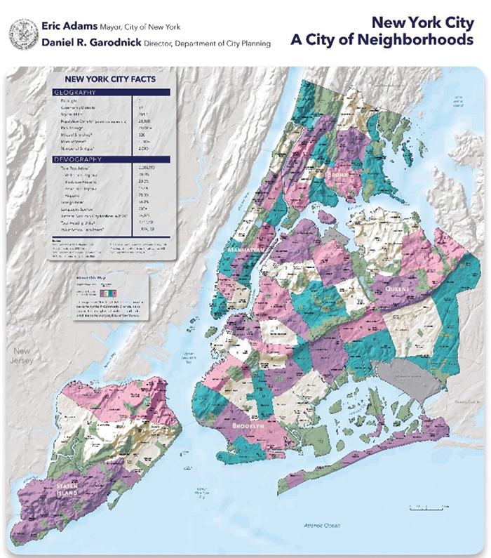
The City of Neighborhoods map.
According to DCP, this 2022 edition of the map – which was first published in 1994 – better represents the hills, valleys, and ridges that define the unique contours of New York City neighborhoods and our surrounding waterways – which have inspired many neighborhood names – than previous maps have.
It offers important statistical information about the Big Apple, including key data from the latest decennial census and American Community Survey. This includes the percent of foreign-born New Yorkers (36.2 percent), the number of languages spoken (more than 200) in NYC, and the total number of housing units enumerated in the 2020 Census count.
In the face of New York’s ongoing housing crisis, these statistics, among many others, are key to planning for a fairer and more affordable city, DCP officials added.
Printed versions of A City of Neighborhoods—available at CityStore—have been enhanced with a QR code linking viewers to the digital version on the DCP’s website.
On DCP’s website, viewers can also find a link to DCP’s popular Population FactFinder (https://popfactfinder.planning.nyc.gov/) where users can explore an array of demographic and socioeconomic data related to 8.8 million New Yorkers. Population FactFinder allows users to define areas for which they’d like to see demographic facts, be it all of Gotham or part of a neighborhood.