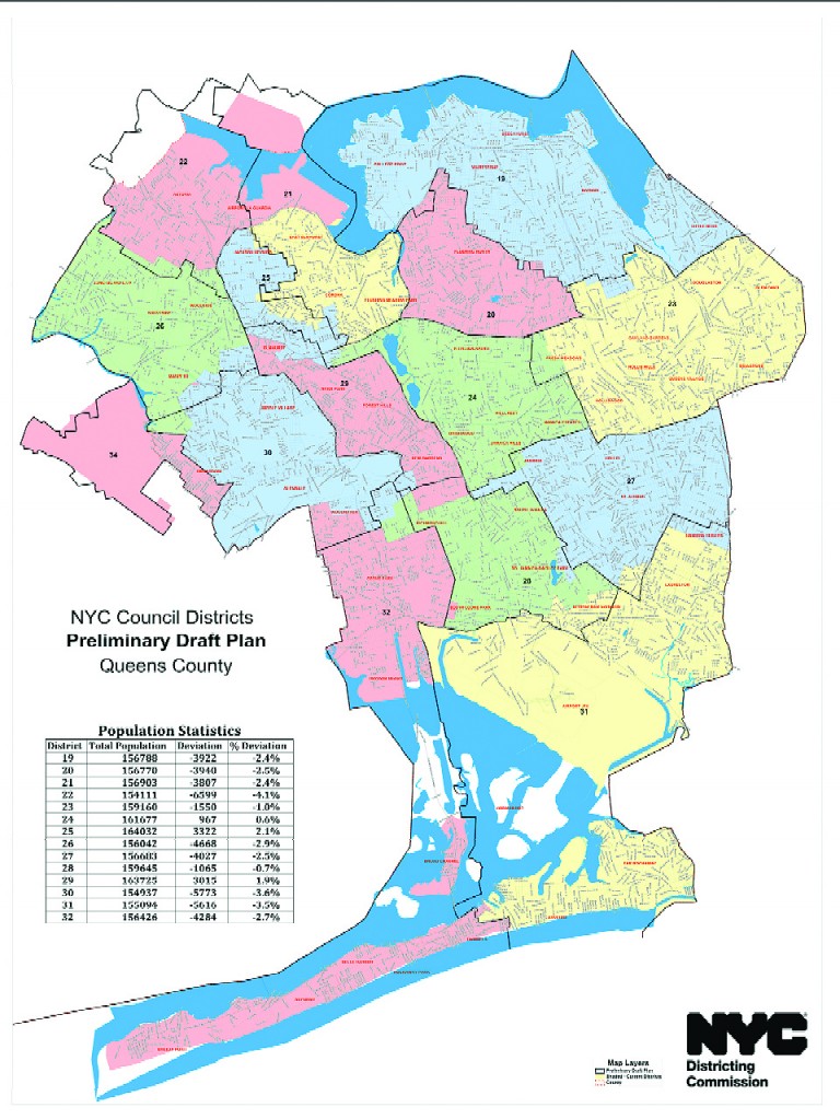

The preliminary City Council map for Queens that the districting commission revealed earlier this month. Photo courtesy of the NYC Districting Commission.
After a series of public hearings and meetings, The New York City Districting Commission released its preliminary City Council maps. Although most districts remained the same overall, changes were made, having an effect on a few communities.
The biggest change in south Queens is the city council representation of Woodhaven and Richmond Hill.
Under the proposed map, Councilman Eric Ulrich (R-Ozone Park) would lose a large portion of the Woodhaven currently in his district
and subsequently add more parts of Richmond Hill to the 32nd District.
Picking up what Ulrich would be losing is Councilwoman Elizabeth Crowley (D-Middle Village). Richmond Hill would then be split between Ulrich and Councilman Ruben Wills (D-Jamaica). Currently, that same sector is divided in four ways between Ulrich, Crowley,
Wills and Councilwoman Karen Koslowitz (D-Forest Hills).
Before the proposed map was released, some Queens residents at the borough’s public meeting on August 21, expressed their hope for a change in the way the lines are drawn in the new map.
Vishnu Mahadeo, president of the Richmond Hill Economic Development Council (RHEDC), called for Richmond Hill, Ozone Park and South Ozone Park to be under one council district.
He said that the way current lines split those communities results in too many districts and dilutes effective representation, specifically referring to the Indo-Caribbean community. Mahadeo says there are about 50,000 people from that community living in those three
neighborhoods combined who come from either Guyana ,Trinidad and Tobago and Suriname.
“This willful splitting of communities of common interest has created a system of disenfranchisement for the indo Caribbean community as their votes are less effective or ineffective,” Mahadeo said in a written testimony submitted to the commission.
Both Albert Baldeo, president of the United Communities Alliance, and James Hong from the Asian-American Community Coalition on Redistricting &Democracy echoed Mahadeo’s sentiments for uniting those three areas.
Mahadeo recommended to the commission that the boundaries for this district should be set at Jamaica/Hillside avenues to the north,
the Belt Parkway to the south, the Van Wyck Expressway to the east and Woodhaven Boulevard to the west.
The next step in the redistricting process is to hold more public hearings that will be based off of the map that was released two weeks ago.
“There are many more views that need to be shared … given the significance of redrawing these lines for the next ten years,” said Benito Romano, chairman of the redistricting commission. “We encourage the public to participate.”
The meetings are scheduled to take place between October 2 and October 11, with each borough having its own meeting, giving residents a chance to speak their mind about proposals for the areas they live in.
The Queens public hearing is set for Wednesday, October 10 at LaGuardia Community College. The address is 31-10 Thomson Avenue in Long Island City. It is scheduled to start at 5:30 p.m and end at 9 o’clock.
By Luis Gronda