Photo: The city is challenging the new flood maps issued by FEMA. Courtesy of FloodHelpNY
With a letter dated last Friday, the city has notified the Federal Emergency Management Agency that it is appealing the January 2015 Preliminary Flood Insurance Rate Maps.
The missive, sent to FEMA Region 2 Mitigation Director Michael Moriarty by Daniel Zarrilli, director of the city Office of Recovery and Resiliency, indicates that the 180-page appeal “demonstrates several errors that were made in the development of the Preliminary FIRMs that undermine their accuracy.”
“In preparation for FEMA’s statutory 90-day appeals period, the city systematically reviewed the underlying modeling used to produce FEMA’s Preliminary FIRMs for New York City,” Zarrilli wrote. “Based on this review, the City is concerned that FEMA has made clear errors in its modeling that need to be addressed…FEMA has made two fundamental errors: 1) the flood models were insufficiently validated; and 2) tidal effects were misrepresented. These errors must be corrected.”
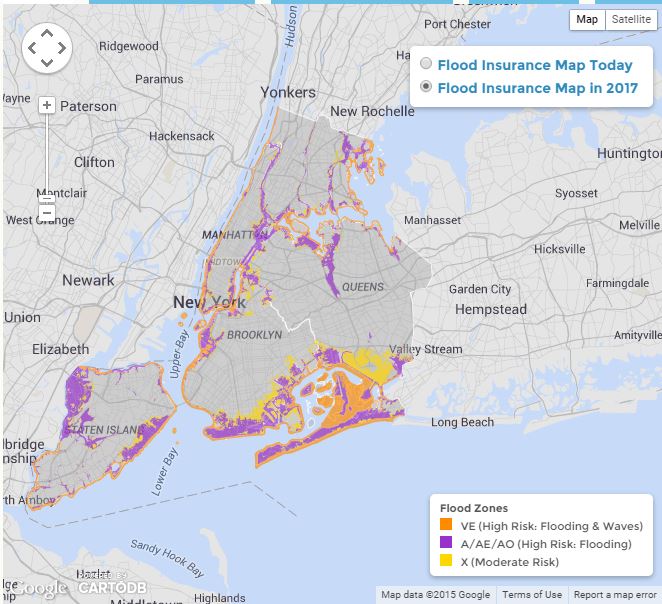
The administration has said that the team of engineers that were hired in anticipation of the appeals period found errors in FEMA’s modeling. The city’s analysis, according to Zarrilli, shows FEMA overestimated the size of the 100-year floodplain and the height of the Base Flood Elevations.
The city said that it’s “critically important” that the flood maps are accurate for three reasons: Homeowners need to understand their flood risk; federal rules require property owners within the 100-year floodplain with a federally backed mortgage to purchase flood insurance; if the maps overstate the 100-year floodplain, more residents than necessitated by the data will be required to purchase flood insurance; and flood insurance rates are set based on the Base Flood Elevation relative to a structure’s first occupied floor; if the Base Flood Elevations are too high the corresponding premium will also be unnecessarily high.
By Michael V. Cusenza
michael@theforumnewsgroup.com